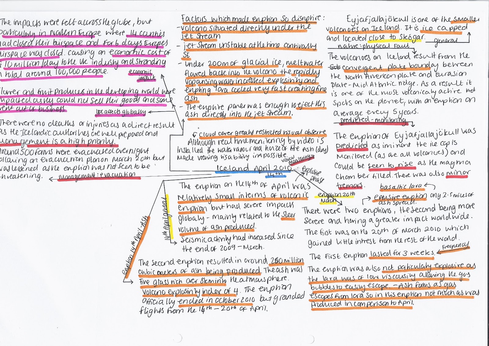
Eyjafjallajokull - Iceland 2010
Mt. Etna - Italy 1991- 3
Mt Etna supports rich agricultural land and it is estimated that 25% of Sicily’s population live on its slopes. Classified as a decade volcano, it has seen an eruption every year since 2001, however, unlike Chaitén it is well monitored and actively managed. Its vulcanism stems from the Subduction of the African plate beneath the Eurasian plate.
It presents significant natural hazard due to the agriculture it supports, with vineyards and orchards spread on its lower slopes and the broad plain of Catania. Etna is a composite stratovolcano and displays a wide array of eruptions,that typically erupt basaltic lava which has a low viscosity (‘runny’) therefore able to travel large distances.
The volcano has the potential to damage the infrastructure surrounding the volcano, as well as large explosive events can lead to the formation of eruptive columns of ash; the fallout from which could present problems to settlement, infrastructure, agriculture and road/air traffic. Flank collapse is a major threat causing a huge avalanche of volcanic debris.
Between 1991-1993 the town of Zafferana was threatened by a lava flow. Earth barriers were constructed but proved useless, explosives were then used to redirect the flow and break up a very efficient lava tube system that had carried the lava 7km down the slope. This proved successful on 23 may 1993 when the lava was successfully redirected.
During the 2002 eruption dams of volcanic rock and soil were built to protect the tourist base at Rifugio Sapienza which helped divert the flow. The Italian army’s heavy earth moving equipment was used to block and divert lava flows. None of the towns on Etna’s slopes were damaged however, there were loses to agriculture and tourism. The Italian government pledged immediate financial assistance of more than $8mil and tax breaks for villagers.
There are only 77 recorder deaths on Etna all of which in recent years can be attributed to accidents and tourists straying of the designated paths.
The current monitoring on Etna is carried out by the Catania INGV which has monitored the volcano for the last 20 years. It has a permanent network of remote sensors (seismic, geodetic, magnetic, gravimetric and video) connected to the centre at Catania by radio.

Mt St. Helens USE - 1980
Cryptodomes are formed when viscous lava forces its way up and causes a bulge. The 1980 eruption of Mount St. Helens was an example. Lava was under great pressure and forced a bulge in the mountain, which was unstable and slid down the north side.
Mt. St Helens is an active composite cone volcano in Skamania county Washington in the NW of the USA. It is close to the subduction boundary of the North American and Juan de Fuca (oceanic) tectonic plates.
In response to the growing threat posed by the volcano in 1980 there were many management schemes. The ‘red’ zone was an exclusion zone where no members of the public were allowed to enter, and the blue zone was restricted access. After the eruption blast helicopters were mobilised to search for victims that had ventured into the exclusion zone and makeshift hospitals were erected near to the affected area.
The ash fall an Yakima was managed by media response telling people to remain calm, immediate aid was requested from the federal and state governments and all emergency services were mobilised. A central communications centre was established in the town hall, and people were urged to wear safety masks to avoid ash inhalation when outdoors – the 3M Company diverted its whole supply of masks to Washington State for anyone who needed them. The city’s municipal airport was closed indefinitely and there was 24 hour monitoring of the city’s domestic water treatment plants to ensure no contamination. The city’s CBD was ordered to close so cleanup could begin along with all public services including schools and buses. Emergency shelters were opened for people who were stranded such as tourists and business people. The National Guard was activated to help with security and clean up.
The eruption began with forewarnings of a 4.1 mag earthquake on 20th March with increasing activity over the days following. Ash began to plume out of the summit after 125 years of dormancy on March 27th. There were concerns over the growing bulge on the north flank on April 30th. On may 18th the day of the eruption a 5.1 mag earthquake was recorded below the summit which triggered the largest landside in history, followed by a lateral blast that levelled 230square miles of forest and killed 57 people and billions of £ in property damage. The ash plume reached 80,000ft in less than 10 minutes and spread up to 22,000 square miles. For 6 years after the volcano continued to add material to the crater floor (97 mil cubic yards). From 04-08 125 mil cubic yards of material produced and 7% of the crater has been refilled with lava, since however, the volcano remains quiet.

LEDC
Soufriére Hills Montserrat -1995
Montserrat is part of a volcanic arc of islands in the Caribbean (still a British territory). In 1995 an active volcano started erupting. The MVO (Montserrat Volcano Observatory has divided the activity into four phases.
Phase 1: Summer 95 – early 98
Soufriere Hills was inactive for over 300 years there were warning signs of volcanic activity. Steam was rising from the vent and mud pools increased in temperature. The first eruption started on 18th July 95 causing the evacuation of Montserrat’s capital Plymouth and exclusion zone on the south of the Island. On June 29th at 1pm 1997 a large eruption occurred sending 5 mil m^3 of rocks and ash down the flanks of the volcano. These pyroclastic flows killed 19 people (who chose to return to their farms in the exclusion zone). The impacts of stage 1 were significant on the local population, as it caused the emigration of over half the islands population.
The activity in phases 2-5 has been significant to warrant the continuation of the exclusion zone.
Phase 2: Dec 99 – Summer 03
Phase 3: Summer 03 – spring 07
Phase 4: summer 08 – Jan 09
Phase 5: Oct 09 – Feb ’10
This phase began after 2 days of decreasing gas emissions and an hour of small earthquakes. Ash vented for the first 4 days as the dome grew and pyroclastic flows were recorded some reached places never before affected. This ended with the 5 vulcanian explosions (powerful eruptions of blocks of viscous lava/volcanic bombs) over 5 weeks Jan-Feb.
On the 11th of February 40 million m^3 (20% of northern lava dome) collapsed, causing many pyroclastic flows and surges. One blast headed down Farm valley (not previously affected) and was described by the MVO as being ‘a small lateral blast type pyroclastic surge’- familiar with the 1980 Mt St Helens eruption (adding 650 m of new coastline at Spanish Point). The pyroclastic deposits are made up of ash and andesitic glass (porous light grey rock ejected at great speed, trapping water vapour from magma as it forms). Some can be less dense than water and floats, some contain crystals of proxene originating from mingling of Basaltic (silica-poor) and rhyolitic (Silica-rich) magma. Further explosions can occur when water comes into contact with hot ash insulated by layers on top, days after the initial explosion.
The 11th Feb event generated ash clouds 12000m high, the SW winds caused the ash flow to fall only on parts of eastern Montserrat mainly falling on Islands inc: Antigua, Guadeloupe, Dominica and St. Lucia. Monitoring
Note: Volcanologists can at least know where eruptions can take place, however, seismologists do not have this slight advantage.
Current monitoring of Soufriere Hills is carried out by the MVO with several stations throughout the island, powered by solar panels to supply a continuous flow of data (however pyroclastic surges, flows and lahars put stations out of service). However on the 11th Feb a monitoring station was only 2m away from a singe zone of a pyroclastic flow. There are also 4 monitoring stations set up by a British-American research project (SeaCALIPSO) containing a tilt and strain meter in a 200m deep borehole. There are also 2 additional stations to detect air pressure variations caused by gas eruptions, as well as webcams on the MVO itself, however, completely useless in heavy cloud cover although there is a thermal camera overcoming the problems of low visibility.
In the 1995 eruption the capital city, Plymouth was destroyed and villages and farmland to the south was evacuated. Agriculture, industry, landforms, land-use, demography, politics and culture have all undergone enormous changes as a result. Montserrat experienced a mass exodus of its population. Between 95-99 the population decreased from 10,000 to 3,000 and rising to just over 5,000 by 2006. The displaced islanders settled mainly in Antigua (a neighbouring island) the UK and the USA. Throughout the 20th century the island has experienced out migration, such as in the wake of hurricane Hugo in 1989. Those that left during the 90’s were predominantly from economically active age groups. Therefore the island experienced a loss of economic potential. Although another impact is that there have been and influx of workers from other Caribbean islands seeking work in mainly in construction.
One on the points of the islands sustainable development plan (08-20) is to achieve a sustainable population. The government hopes to develop and implement population, labour and immigration policies to enhance the growth of the population, and to attract its current population with new initiatives as well as to facilitate the growth in population.
Some of the people affected by the eruption have stayed on the island have experienced worsening of respiratory diseases (however these have been well controlled), caused by christobalite, an element found in ash. Although there have bee other health issues such as post traumatic stress disorder, not aided by the crowded evacuation centres post eruption.
Enrolment in all streams of school dropped from 2,672 in 95 to 620 in 98, causing the amalgamation of the two secondary schools on the island. Although there was problems in staffing the schools as most came form other Caribbean islands (8/35 staff left the school at the end of 2009). Since, a new community collage has opened next door to the secondary school in 2005, with new methods of teaching to improve the education and set put students on better footing for the future.
Economic impacts
The island is still struggling to deal with the economic impacts from the eruption. The land adjacent to the volcano was the most fertile, but was made agriculturally useless by the eruption, putting 300 farmers out of work. The island was previously self sufficient with many crops, but now relies heavily on imports (it was once famous for its lime crops which are now hard to come by). Although following a government campaign many households grow their own crops.
Manufacturing
The island hosted assembly-type and food production plants before the eruption, and the industry was strong dominated by rice mills. Until the evacuation on the capital city the island hosted its own offshore medical school (the American university of the Caribbean) which employed dozens of staff and 400 students – significant spenders in the local economy. Future plans to rebuild the economy include increasing the ash processing industry, and construction of a new capital city in Little bay.
Tourism
The airport and port were in the exclusion zone with huge areas of the island out of bounds and advice given to tourists not to visit the industry suffered greatly. In 04 a £5mil grant was secured form the department for international development, some of which used for hotel and villa construction and some on hiring a consultant’s team from Scotland called ‘team tourism’. Targets were made to widen their tourist base. At the height of the eruption in 2007 the annual number of tourists was 4,000, by 04 a ferry twice a day linked Montserrat with Antigua with the estimated number of tourists reaching 15,000. However this ferry service ceased in 2005 and numbers shrunk to 9,500, Caused by the limited size of the airport and ferry.
Energy
Is one of the economic challenges facing the island. It relies upon insufficient diesel generators. The islands sustainable development programme identified renewable energy identified it as a priority. Geothermal energy id the main focus, with solar tidal and wind not efficient enough due to the location and other factors and a suitable aquifer and fresh water has been found in foxes bay in zone c of the exclusion zone. The planned capacity of this small plant would be 2-3 MV, enough to sustain the current population size. However, the project is struggling to fund meaning that the island is still susceptible to rising oil prices.
Environment
The ash from the 11th Feb eruption disturbed air travel over neighbouring Caribbean islands, mainly eastern Caribbean, as well as causing millions of pounds of damage to banana and other cash crops. Te eruption also destroyed 1/3 of the islands tropical rainforest and wildlife slowing the growth of vegetation in the short term.
(although after time will improve the fertility of the soil)
Chaitén Chile - 2008
Chaitén volcano is located in south-eastern Chile, on a Subduction zone between the Nazca (Oceanic) plate boundary and the South American (continental) plate boundary. On May 2nd 2008 Chaitén erupted for the first time in 9,400 years, therefore was not considered and active threat. The volcano is one of many along the Nazca-South America plate boundary, with Chile having one of the longest active volcano chains in the world. The volcano which featured a lava dome within a caldera about 2.5km wide and 4km long is composed if viscous rhyolitic lava and pyroclastics. It is a caldera volcano, resulting in explosive eruptions from the build up of pressure and gas.
The initial eruption produced a plume of volcanic ash and steam that rose 17,000 km high. This was carried over the Andes into neighbouring Argentina and over the Atlantic. This caused flights to be diverted in Argentina and airports to close. Hundreds of domestic and several international flights were cancelled impacting both governments up to $2 million. The town of Chaitén had a population of 4200 and was situated 10km south of the volcano. The town was covered in a thick layer of ash, causing the deaths of many animals due to asphyxiation. However there were no deaths to inhabitants as a direct result of the eruption (although one death caused by shock). 4000 of the town’s residents were evacuated by boat, along with another 1000 residents from the nearby town of Futaleufu. Smaller settlements to the south east such as Chubut and Rio Negro also received heavy ash fall.
Timeline - First earthquakes were felt late on the 30/04/08 with the eruption beginning 01/05/08. There were nearly continuous ash emissions as high as 30km with intermittent large explosions continuing 2nd-8th of May. By late May the lava eruptions had generated a new dome (around 54,999m^2 in an area containing 55 million m^3 of new material). The height of the ash column is estimated at 20-30km at its peak. The subsequent collapse of the column brought a vast amount of ash onto the surrounding area. This Asphyxiated some animals, blocking roads and causing thunderstorms. Passing polar storm also meant that heavy rain combined with heavy rains causing flooding. By May 14th officials had announced that 90% of the town was flooded due to increased flows of the Rio Blanco and Rio Chaitén.
The volcano is not accurately monitored and the nature of the eruption gave serious cause for concern. As the rhyolitic nature of the lava and ash meant that an eruption was likely dominated by pyroclastics (aside from some reports of lava this was the case). The USGS reported that the ashfall had significantly impacted local communities. Lahars generated by intense rainfall cut communications making access difficult. Ash falls up to 15cm deep had blocked rivers and contaminated groundwater supplies.
Many animals were killed due to ash inhalation resulting in farmers loosing livestock and produce (if/when there farms were again inhabitable).Local hospitals treated many people for breathing difficulties. Up to 90% of the down was damaged and up to 30% completely destroyed (as well as flooding) , damage to airport and marine facilities hampered rescue attempts.
Chaitén airport was closed indefinitely (inc closures at Osorno, Puertto Mont – Chile and Bariloche, Esquel, Comodro Rivadavia – Argentina)
Prior to 2008 Chaitén was considered a low threat volcano although records showed it to be an explosive volcano; the length at which it had lain dormant meant it was not actively monitored. The remote location of Chaitén and low population density meant that it was not a high priority. Chile has only 20 volcanoes with completed geological studies seven of which have completed hazard assessments and seven more monitored to some degree. There is only one volcano observatory in Chile and until the USGS arrived on May 16th (14 days after the initial eruption) there was no real monitoring of the volcano.
The immediate threat the eruption posed caused the evacuation of over 4000 people (by the 3rd May the Chilean navy helped evacuate 3900) with forced evacuation orders. Emergency measures were also put in place including: Residents were told not to drink the water due to ash contamination; Officials distributed fresh water and protective masks; a 50km exclusion zone was placed around the town; the government issued monthly financial support to each family of between $1200 and £2200; and financial aid to small businesses was granted and a 90 day freeze on payments of loans to the state bank Banco Estado to help get businesses back on their feet. The town resembles a ghost town as people fear returning to it.
A key development and positive outcome of the disaster was the VDAP Volcano Disaster Assistance programme to aid monitoring and prediction of future eruptions. Real-time seismic monitoring began on 17th May. As a Volcanic Exclusivity Index VEI category 5 eruption (>1km^3 magma ash to 20+km) the monitoring was seen to be important in helping the Chilean government model future explosive rhyolitic eruptions. The volcano continued to experience minor eruptions for the duration of 2008, highlighting the difficulties agencies face in dealing with the aftermath of one volcanic event.