Plate tectonic theory and plate margins
The earth dates back around 4.6 billion years, in which time it has been ever changing. Starting off as a gaseous ball of fire and rock, the earth has cooled tremendously, enough so that it’s formed a ‘crust’ which we now live on. A simplified time scale of the history of the earth can be taken from Nigel Calder’s book The Restless Earth.
 ‘We can depict Mother earth as a lady of 46, if her “years” are mega centuries... the deeds of her later childhood are to be seen in old rocks in Greenland and south Africa . Like human memory, the surface of our planet distorts the record, emphasising more recent events and letting the rest pass into vagueness - or at least into unimpressive joints in worn down mountain chains. Most of what we recognise on Earth, including all substantial animal life, is the product of the past six years of the lady’s life...flowering plants did not appear until she was 45 - just one year ago. At that time the great reptiles, including the dinosaurs, were her pets and the break-up of the last supercontinent was in progress.
 |
| Fig 1 |
It was as early as 1620 that theory of plate tectonics began to emerge, (just over a minute in Calder’s timescale). It was Francis Bacon who introduced the idea that the plates fit together much like a jigsaw and that they must once have been joined together. He saw the likeness between the east coast of South America and the west coast of Africa (Fig 1). However, it was only in the early 20th century that the theory was developed, when in 1912 a German meteorologist Alfred Wegener published his theory that all the continents were joined in one supercontinent he named Pangaea (Fig 2). Wegener’s theory develops the ideas of continental drift, but was only fully accepted by the geoscientific community after the concepts of seafloor spreading were developed in the late 1950s and early 1960s.
Since the initial ideas were introduced a great mass of evidence has emerged to support the theory, however, Wegener was restricted to what was available at the time. Despite this he collated strong supporting evidence from several different scientific areas. Wegener studied the fossil records that had been found on the eastern coast of Africa and Western coast of South America, which showed the Mesosaurus, a small reptile that lived in Permian times (about 280 million years before the present, at the time Pangaea formed). The fossil was found only in South Africa and Brazil. As well as a plant that existed when coal was being formed around 345 million years before present day, which was found only in India and Antarctica. The geology of the Eastern coast of America and Western coast of South Africa also corresponds with the theory as rocks of similar age, structure and formation occur in both places. The Appalachian Mountains in eastern USA also match geologically with those in North West Europe. Lastly Wegener looked for evidence left by the climatology that would have been around 280 million years ago. He did this by looking at coal formed in areas that may once have been joined together. Coal found beneath the Antarctic ice cap was formed under the same warm and wet conditions as coal found in tropical Brazil and central India, and evidence of glaciations has also been found in both these places. Britain also shows a history of glacial activity as rocks such as coal, sandstone and limestone could not have formed in its present climate.
 |
| Fig 2 |
 Wegener’s pooled information from several subject areas to produce his theory of continental drift. However, his ideas were rejected by specialists. This was due partly to himself not being regarded as an expert but mainly because he was unable to produce an explanation of the mechanism of continental drift. He was unable to explain how a solid continent could freely move around the earth.
Since Wegener’s theory was first put forward new evidence emerged during the 1950’s and 60’s, this being the discovery of the Mid Atlantic ridge, the studies of palaeomagnetism in the 1950’s and the discovery of sea floor spreading. The mid Atlantic ridge is a constructive plate boundary formed by the meeting of the Eurasian and the North American plates. It was discovered while investigating islands in the Atlantic in 1948, Maurice Ewing noted the presence of a continuous mountain range that was around 1000km wide and 2500m in height. It was also noted that the rocks found here were formed by recent volcanic activity, later investigations also show similar under sea mountain ranges (thought previously to have been formed by ancient volcanic activity) in the eastern pacific stretching nearly 5000km, known now to be the boundary between the Australian and Pacific plate.
 Studies of palaeomagnetism began in the 1950’s and involved studying the rocks formed by underwater volcanic eruptions with relation to the earth’s magnetic field. When basaltic lava cools on the sea floor individual minerals separate - especially iron, these minerals then align themselves on the sea floor in the direction of the magnetic pole (Fig 3). New technologies allow these rocks to be dated and with information (known before 1950) that the earths magnetic pole varies from year to year and (a more a recent discovery) that the earth’s magnetic field reverses periodically, it is possible to see an identical pattern between rock formations on either side of the mid Atlantic ridge. It has been claimed that there have been 171 reversals in 76 million year’s; these reversals show that when new basalt formed and the pole was on the south it aligns with that formed at the same time on the other side of the ridge.
  |
| Fig 3 |
The last recent discovery was that of sea floor spreading. In 1962 Harry Hess dated the rocks of the Atlantic sea bed from the ridge itself outwards to the coast of North America. He discovered that the newest rocks were at the centre near Iceland, and the oldest at the coast. However the conflict with the idea of sea floor spreading was that of the earths surface expanding and evidence of plate destruction was needed to prove this wrong. This evidence was found along the edges of the Pacific Ocean where a destructive plate boundary lies between the Pacific, Philippine, North American and Australian plates. It came from the plotting of major earthquakes and volcanic eruptions, which led to the development of the theory of plate tectonics.2
The structure of the earth was thought for many years to be a mystery, however, by studying earthquakes geologists could for the first time work out what lay beneath the crust. At the ‘Moho’ (Mohorovičič) discontinuity geologists found that shock waves from seismic activity travel faster, indicating a change in structure from solid to liquid. The ‘Moho’ discontinuity is the junction between the earths crust and the mantle; it varies in depth depending on the type of crust above it. The average depth under continental crust is around 35-40km, under mountain chains it’s around 70km and under oceanic crust it’s at 6-10km below the surface. Scientists were able to work out the structure of the earth by measuring how fast seismic waves travel from the focus of an earthquake, as different types of waves travel at different speeds through different densities.
The earth is made up of 3 distinct layers, the crust the mantle and the core. The crust is the outermost ‘layer’ and the thinnest. The visible part of the crust that we see is known as the Pedoshpere, comprised of soil , it is the uppermost part of the lithosphere which reacts to the atmosphere, hydrosphere and biosphere through soil forming processes. The crust and the rigid top layer of the mantle are known as the lithosphere, and is the uppermost part of the mantle, it remains rigid for long periods of geologic time deforming through brittle failure or gradual stretching. There are 2 types of lithosphere, oceanic and continental, the lower part of the lithosphere consists largely of peridotite. A dense, coarse-grained igneous rock formed through the cooling and solidification of magma or lava.
 Oceanic lithosphere is around 50-100km thick (however beneath mid ocean ridges it is no thicker than the crust) the oceanic crust is around 6-19km thick (average density 3.0) and consists of younger denser rock of basaltic composition, dominant in minerals of manly silica and magnesium (Sima). Continental lithosphere has a range in thickness from about 40-200km; however, the upper 30-50 km is crust. It is composed of lighter older rocks of granitic (average density 2.6) and some basaltic types, dominant in minerals of mainly silica and aluminium (sial). The crust is separated from the mantle by the ‘Moho’ discontinuity; which is distinguished by the change in chemical composition. The asthenosphere is a region of the upper mantle which is situated directly under the lithosphere (100-200km below the surface) it is highly viscous, weak and deforms under stress unlike the lithosphere. The boundary between the lithosphere and asthenosphere is defined as a difference in response to stress, as the asthenosphere deforms to accommodate strain where as the lithosphere is much more brittle. The core is the innermost layer made up of iron and nickel it is divided into two parts. The outer core is in a semi-molten state but the inner core - discovered in 1936 is solid, it is 6371 km below the surface and around 6200°c.2
 |
| Fig 4 |
The lithosphere is broken into tectonic plates; there are seven major and several minor plates (Fig 5). Although the plates themselves are rigid they flow freely over the surface of the earth on the underlying asthenosphere. The plates form different boundaries dependant on their type and relative movement at each boundary. The resulting boundaries can either be constructive (divergent), destructive (convergent) and conservative (transform) plate boundaries. Volcanic and seismic activities as well as mountain-building and oceanic trench formation can occur along all these boundaries. The plates themselves are moved by currents which form convection cells. The currents are created as a result of the underlying lithosphere having a higher strength and lower density than the asthenosphere. The currents are generated through the lateral variations in density through the mantle with the dissipation of heat from the mantle supplying the original source of energy driving plate movement.
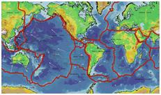 |
| Fig 5 |
 Convergent plate boundaries (also known as destructive plate boundaries) form when a plate with continental crust moves towards a plate with oceanic or another continental crust, forming a Subduction zone or a continental collision. This is dependant on the types of plates involved. A Subduction zone normally occurs when oceanic crust is sub-ducted under the continental crust (Fig 6). This is due to the continental crust being more ‘buoyant’ due to the nature of the rock. Continental crust is older than oceanic crust and therefore lighter, the heavier oceanic crust is forced under the continental crust where it is melted back into magma. Collision zones (collision plate boundaries) occur when continental crust meets another continental crust the resultant force over millions of years forces one crust to ‘buckle’ the resultant landforms are large mountain ranges known as fold mountains, such as the Himalayas and the Alps (the collision between India and Asia has been continuous for around 50 million years). Along this boundary both volcanic eruptions and seismic activity take place.
The process of Subduction produces deep sea Trenches parallel to the plate boundary as well as island arcs with volcanoes. The Marians Trench is an example of a deep sea trench at over 11 km deep. It is located in the west Pacific Ocean and is produced by the Subduction of the Pacific plate beneath the Philippine Plate. The Peru-Chile sea trench is another example off the west coast of South America it is formed by the Nazca Plate sub ducting under the South American Plate which formed the Andes.
 |
| Fig 6 |
 New Zealand lies on a destructive plate margin between the oceanic crust of the Pacific plate and the continental crust of the Indo-Australian plate. On its south island the volcanic activity has created a deep sea trench ‘Tonga-Kemadec’. This has resulted in the creation of numerous volcanoes and frequent seismic activity. The Subduction has pushed the edges of the continental plate upwards forming Fold Mountains called ‘the southern Alps’. Most of the seismic and volcanic activity on the Island is located in a 20-40km wide Taupo volcanic zone, stretching for 300km from mount Ruapehu to white island forming part of ‘the ring of fire’ – a ring of volcanic and earthquake hotspots that lines the edge of the Pacific plate. Since 1886 5 volcanoes have erupted in the zone, apart from the permanently active white island, Ruapehu is the most recent in 1996. The eruption ejected steam and huge rocks as well as causing several lahars. This resulted in many roads, railway lines and even airspace to close. However the biggest loss was to the tourist industry as two skiing season were lost.
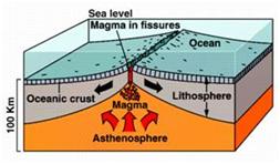 |
| Fig 7 |
 Constructive (or divergent) plate boundaries (Fig 7) are formed when two plates move away from each other; this is known as sea floor spreading (when involving oceanic crust). It occurs most actively between oceanic plates and forms mid ocean ridges such as the Mid Atlantic ridge, where the Eurasian and North American plates are being forced apart by convection currents in the asthenosphere. Divergent boundaries between continental plates create rifts which form valleys. As the plates move apart magma rises through the gap to form new volcanic rock, which initially forms sub marine volcanoes that may grow to above sea level over time. An example of this is Iceland which sits directly atop the mid Atlantic ridge with a chain of volcanic activity running down its centre. The landmass is gradually growing as the plates are pulled apart and new rock forms; Surtsey is a volcano in the south of the island.
 |
| Fig 8 |
 Conservative (or Transform) plate boundaries (Fig 8), such as the San Andreas Fault in California occur when two plates move parallel to each other. Frequent seismic activity occurs at these plate boundaries, with the boundary being characterised by the pronounced transform fault visible where rock is neither created nor destroyed. The San Andreas Fault forms the junction between the North American and pacific plates. Both plates are moving in a North West direction however, the pacific plate at a faster rate creating the illusion that they are moving in separate directions. The last major earthquake to occur was in 1989. If these plates continue to slide past one another Los Angela will eventually be an Island off the Canadian coast.
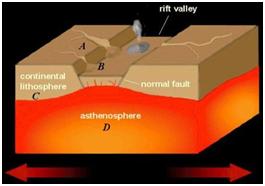
 An exception when looking at the three types of plate boundary is the great African rift valley. The Atlantic Ocean was formed as the continent of Laurasia split in two (Fig 2), this may be a process that is repeating itself today. In East Africa the brittle continental crust has fractured leaving the broken section to drift apart (Fig 9). The central portion dropped down to form the great African rift valley (Fig 10) extending for 4000km from Mozambique to the red sea. Its width varies between 10 and 50 km but its sides can reach 600km in height. Where the land has dropped significantly it has been invaded by the sea - in this case the red sea.
 |
| Fig 9 |
 |
| Fig 10 |